

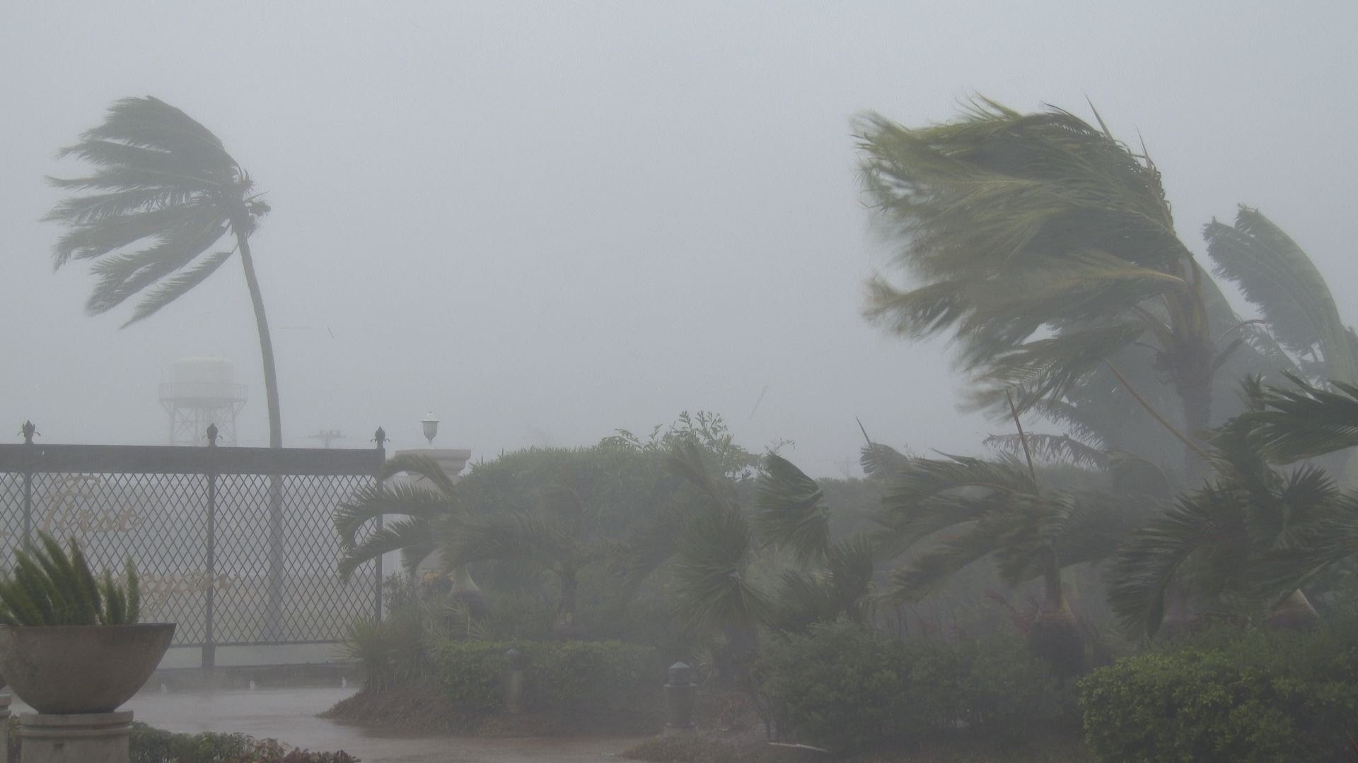
Every year, as the calendar flips to April, discussions and anticipations about cyclogenesis start to take place. For people like me who observe meteorological events closely, it's time to check daily updates. Amidst the COVID-19 crisis, Super Cyclone Amphan (pronounced UM-PUN) has emerged as a major threat to the Indian coastline. It is only the second super cyclone in the Bay of Bengal after the devastating Super Cyclone of Odisha in 1999, and it has the potential to recreate that kind of devastation.
Introduction and Meteorological History
There must be something very interesting or really important to make me think about writing an article during the life of a cyclone, rather than writing a case study after the destruction. Super Cyclone Amphan is one such case. The cyclone was named based on a suggestion by Thailand, following the global procedure for cyclone naming, which I will cover later.
The journey of Amphan started with a low-pressure area around May 13th in the Andaman Sea. Things escalated when it became a cyclonic storm on the evening of May 17th, and within the next 12 hours, it turned into a super cyclone, which no one had imagined. Even as I write this, the system is traveling in highly favorable conditions.
Types of Cyclones
You might be wondering what makes favorable conditions for cyclogenesis. Let's discuss the categories of cyclones before delving deeper into this. Understanding some basics will help.
There are several scales, the most widely known being the Saffir-Simpson Hurricane Wind Scale, primarily used in the Americas. In India, the IMD classifies storm categories into seven parts. These types are listed in the image below:
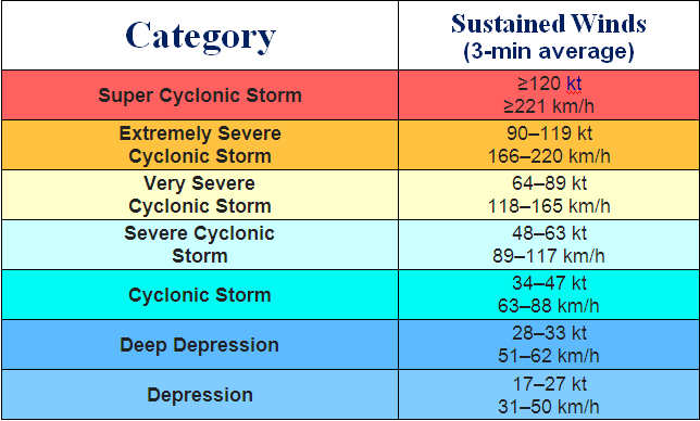
Since Super Cyclone Amphan has gusts of 240–250 km/h with sustained winds up to 275 km/h, it is categorized as a super cyclone.
Trajectory or the Path of Super Cyclone Amphan
Currently, it is moving nearly northward and is in the process of recurving, with a speed of 15 km/h. It is situated 640 km south of Paradip and 800 km south-southwest of Digha. It will make landfall by the afternoon or evening of May 20th, near the Sundarbans between Digha and Hatiya Islands of Bangladesh.
Since the coast of West Bengal is shallow and a basin area, the impact would be catastrophic, triggering extensive damage to structures and trees. It is well-advised to evacuate the adjoining areas well in advance. I will detail the impacts in the later sections.
Affected Areas
The super cyclone is set to impact the shallow coastlines of West Bengal and Bangladesh, but its massive size will also affect Odisha, West Bengal, Sikkim, and the entire northeastern states, particularly Assam and Arunachal Pradesh. I will post updates on my Twitter handle and Facebook regarding further intensification and status.
Features of Amphan
This section highlights the characteristics and potential havoc of Amphan.
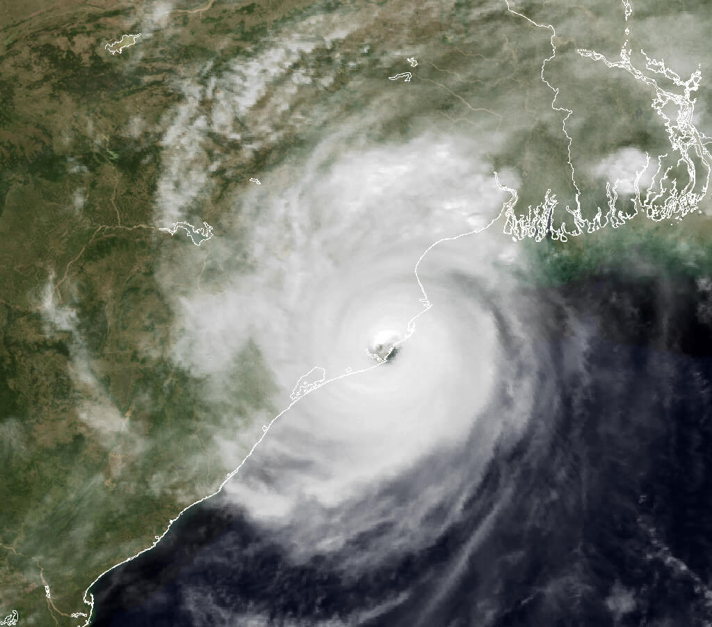
Super Cyclone Amphan has wind speeds of 230–240 km/h with gusts up to 275 km/h. It has the second-lowest pressure at its center at 918 hPa (the lowest being the Super Cyclone of 1999 with 912 hPa). Lower pressure leads to more destructive cyclones. Amphan has an expansive system with cloud tops of 1111 km, featuring super-dense, deep, and symmetrical central convection. Its height is about 15 km with an eye radius of 120 km. It might be the largest cyclone in dimension ever recorded. It can cause tidal waves up to 4–6 meters and might dump saline water up to 25–30 km inland, causing massive inundation.
How Cyclones are Named
Cyclone naming is a global procedure for easier media reporting. Technical terms are alphanumeric and difficult to communicate. For example, Super Cyclone Amphan's technical name is Tropical Super Cyclone 01B. In the North Indian Ocean, cyclone names are suggested by a group of adjoining countries.
Cyclone: A Multi-Hazard
When a cyclone hits, it brings three-dimensional damage:
- Tidal Waves: These cause debris, soil salinity, inundation, and damage to standing crops and structures, especially kutcha houses.
- Heavy Rainfall: Cyclones can trigger massive rainfall and cloud bursts. For instance, Puri recorded 54 cm in 24 hours during the Odisha Super Cyclone.
- Strong Winds: Strong winds rushing from the sea contribute to the damage. For Amphan, North and South 24 Parganas will experience winds up to 165 km/h, gusting to 195 km/h, and Kolkata will see winds of 110–120 km/h, gusting to 135 km/h.
Parameters for Cyclogenesis
You might wonder how cyclones originate and what makes Amphan so powerful. There are six major factors behind cyclogenesis. The first three are thermodynamical parameters, and the last three are dynamic parameters:
- Sea Surface Temperature (SST): For cyclogenesis, the SST should be above 26°C. Currently, the Bay of Bengal is at 35°C, leading to Super Cyclone Amphan.
- Higher Relative Humidity: At least 60% RH in the tropospheric level enhances deep convective activities.
- Atmospheric Instability: This helps moist air rise quickly, promoting evaporation.
- Coriolis Force: This force, due to the Earth's rotation, causes wind deflection. Cyclogenesis needs minimum Coriolis force found north of 5° latitude.
- High Rotating Power: The lower atmosphere needs high rotating power for cyclogenesis, leading to cloud rotation.
- Low Vertical Wind Shear: Lower winds at the upper level are needed to organize clouds for cyclogenesis.
Other factors like Madden-Julian Oscillation (MJO) and Kelvin Wave also play a role.
Effect on the Monsoon
Super Cyclone Amphan caused the early arrival of the monsoon over the Andaman & Nicobar Islands. However, its power will dry up the sea's moisture, weakening the monsoon surge. This will delay the monsoon by at least two weeks. I now predict the monsoon to arrive around June 1st (+/- 4 days).
Aftermath
The aftermath will be assessed after the cyclone dissipates. Meteorologically, it will shift wind patterns to north-western directions, causing heat-wave conditions over the plains.
Conclusion
Given the situation and conditions, the sea will be very rough. As it is set to hit the delta region, the impact will be catastrophic, similar to Cyclone Nargis but potentially more intense. It is crucial to take advisories seriously and carry out evacuations.
(Based on personal knowledge and the session of DGM of IMD Dr. M. Mohapatra's live session minutes. Information on the current status of Super Cyclone Amphan is attributed to IMD.)